Duisburg Inner Harbour
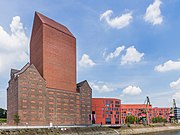
Former central harbour of DuisburgThe Innenhafen (Inner Harbour) in Duisburg, Germany, is connected to the Rhine River, encompasses an area of 89 hectares (220 acres). For over a hundred years during the high point of the Industrial Revolution, it was the central harbour and trading point of the town. Since the mid-1960s, the importance of the harbour declined and it lay in a disused condition for 20 years, before plans for renovation were drawn up. This former industrial area has been fundamentally transformed, a process which started as a part of the International Building Exhibition Emscher Park (IBA) which ran from 1989 until 1999.
Read article


Top Questions
AI generatedMore questions